
A fast-moving wildfire in Los Angeles produced dramatic footage on Monday, as it grew from one acre to 30 in under an hour. Some experts think the fire is likely a preview of the dangerous conditions Southern California will face later this week, as a heat wave combines with katabatic winds. Here’s why those conditions make wildfires inevitable.
What Are the Santa Ana Winds?
As the Great Basin—a high-altitude desert that spans parts of Nevada, Utah, Idaho, and Oregon—begins to cool in the fall, that dense, heavy air seeks out the path of least resistance as it invariably flows downhill. Additionally, the winds around high-pressure systems in the Northern Hemisphere blow clockwise. So when a high-pressure system forms over a cooling Great Basin, it forces that air to blow toward Los Angeles from the northeast.
Air flowing from the high desert down to sea level is subsiding, which means that as air loses altitude, it is compressed. Compressing air causes it to warm. “If you take a piece of air located only mile above your head, and brought it down to your feet, it would wind up 30 degrees Fahrenheit warmer than when it started,” explains Robert Fovell, a professor of atmospheric and oceanic sciences at the University of California at Los Angeles, on the school’s website. “You don’t need to change the altitude of air very much to alter its temperature significantly.” Much of the Great Basin is around a mile higher in elevation than L.A.
Moreover, several large mountain ranges lie between Nevada and Los Angeles. As the already warming air flows over those mountains, it is further compressed, so it blows even faster and raises the temperature. The Los Angeles Basin is framed by the Tehachapi and San Gabriel mountain ranges, which border the urban conurbation to its north and east, the directions the winds are coming from. So as the Santa Ana winds enter the basin, they experience one last compression event before accelerating down the southwestern slopes of those mountains into populated areas.
But along with the speed and temperature of the Santa Ana winds that makes them so conducive to wildfire, they’re also so dry that they’re capable of actually sucking moisture out of vegetation. This occurs not only because the Great Basin is a desert but also due to all the aforementioned compression. The Santa Ana winds start dry, then get even drier as compression causes them to heat up. Their relative humidity is often under 10 percent by the time they reach L.A.
“Relatively dry air is thirsty air, and takes moisture from wherever it can, including your skin and plant life,” writes Fovell. “Increase its speed, and very dry air can desiccate vegetation very quickly.”
Is Climate Change a Factor?
When the Santa Ana winds are blowing, the Los Angeles area experiences high temperatures, extremely low humidity, and high wind speeds. The sources of fuel that drive wildfires are made more prone to combustion, and the winds rapidly spread embers over long distances, spreading any fire that does start and making it harder to fight.
Thankfully, Santa Ana winds blow during the fall, at the beginning of Southern California’s rainy season, although that’s changing. Since 1970, California’s fire season has grown by 78 days and is close to becoming year-round. Rains that used to come in the fall would mitigate the risks created by the Santa Ana winds, but now those winds find still dry fuel that’s been baking in the hot sun all summer long. Extreme winter-weather events—now more common in the area—exacerbate the problem by creating an explosive growth in grasses and brush, which then die and dry out throughout the summer.
While researchers predict that climate change will shift Santa Ana wind events to later months in coming years, the expanding fire season that’s also being caused by climate change seems likely to ensure that those later winds will still find dry fuel sources. And a University of California study found that climate change causes and will continue to cause Santa Ana winds to have even lower relative humidity.
How Do These Fires Start?
Twenty-five million people live between San Diego and Ventura, California, along with all the attendant infrastructure such a massive, concentrated population requires. Southern California’s electrical grid doesn’t appear to be as problematic as that in the northern part of the state, but the local electricity provider is still considering turning power off for up to 500,000 people this week, in an effort to avoid accidental fires as lines blow in the powerful winds.
In addition to power lines, accidental fires can be caused by almost innumerable factors. Vehicle traffic, homeless encampments, trash disposal, smokers, and campfires have all been blamed for massive fires in recent years. And the heightened amount of publicity wildfires receive even appears to attract arsonists.
With so many people living in what is effectively a tinderbox, it’s inevitable that fires will ignite. Weather conditions like those the region is experiencing this week amplify the odds that blazes will spread out of control.
Could Controlled Burns Help?
It’s popular in regressive political circles to criticize California’s government for failing to take steps to adequately mitigate fuel loads.
While it’s true that controlled burns and mechanical thinning are effective tools for reducing wildfire risk and severity, they are also incredibly laborious to implement. Both the burns and the thinning need to be carried out largely by hand and conducted during the ever shortening rainy season, when the risks of a burn or mechanical equipment starting a fire or allowing one to get out of control are minimized. Because brush grows back quickly, especially in California’s current cycle of large winter storms, those fuel-mitigation activities need to be repeated regularly. That used to be once every ten years. In today’s environment? Who knows.
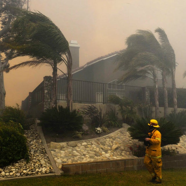
Adding to the headaches involved with fuel removals are the amount of homes that have been built in the wildland-urban interface (WUI), which is basically any developed area with natural beauty. If you saw the videos from Monday’s fire in the Pacific Palisades, those homes’ proximity to the chaparral that’s catching on fire is a textbook example of the WUI.
Fire spreads incredibly quickly on steep, brush-covered hillsides, creating something of a catch-22 for fire-management officials. Burning brush on the steep hillsides below those multimillion-dollar homes could reduce the risk those homeowners face, but it also puts multimillion-dollar homes at risk of an accident caused by the controlled burns. And it exposes residents to potentially harmful smoke inhalation. Plus, those burns would need to be repeated at least once every ten years.
An area the size of Maryland is in need of fuel mitigation in California right now. Neither the state nor the federal government has the resources to do that, and even if they declared an emergency and somehow managed to figure it out this winter, the process would need to be repeated in a decade on what will likely then be an even larger area.
If all this sounds like bad news, that’s because it is. In California, 5.1 million homes are at risk from wildfires exacerbated by climate change. That’s 120 times more homes than are at risk from sea-level rise in the state. There’s no easy answer to this and no solution on the horizon. Is your home at risk? Use this mapping tool to find out.